


ABC News
 ABC News(NEW YORK) — Major, even historic, river flooding is occurring in parts of the Plains and Upper Midwest and will persist through the weekend and into early next week.
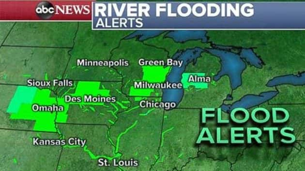
There are still flood alerts due to river flooding from Kansas to Michigan. There are also flood alerts for parts of upstate New York and upstate Vermont due to the risk of ice jams and river flooding through Saturday.
The river flooding is a result of melting snow, rain earlier this week falling on frozen ground and developing ice jams in creeks and rivers. Rising rivers are putting pressure on levees and dams in the region.
Overnight, there was a flash flood emergency in parts of eastern Nebraska, outside of Omaha, due to so many roads being completely impassable.
There have been evacuations and rescues in parts of the Plains and Upper Midwest, especially in a large area of eastern Nebraska. In some cases, flooding has isolated towns in the region.
The Platte River, near Ashland, Nebraska, has broken a record, last set in 1997. This river is responsible for overtopping levees in this region.
Meanwhile, the Missouri River in Plattsmouth, Nebraska, is also in major and record flood stage. The last record was from June 2011. The Missouri River is also rising downstream in St. Joseph, Missouri, and Nebraska City, Nebraska.
The good news is there is no notable precipitation forecast for this region through the next week.
Quiet weather coast to coast
A couple of snow showers are moving off the Great Lakes on Saturday morning, but most precipitation has left the eastern U.S. A couple of heavy rain showers lurk south of New Orleans, but most activity should be suppressed to the south on Saturday.
Radar and satellite are showing very little in the way of storm activity across the entire country. High pressure is building through the western and central U.S. and pushing storm activity north of the United States, while suppressing the ingredients needed for thunderstorms south of the country.
Much of the country will enjoy a decent March weekend, especially since the last several weeks have seen significant blizzards, major flooding in California, powerful wind storms in the central and northeast U.S., a tornado outbreak that killed more than 20 people in Alabama and now record river flooding.
High pressure will cause a gradual warming over the next few days in the West, and some seasonably cool temperatures in the central and eastern U.S. It is cooler in the Southern Plains, where temperatures are around 10 to 15 degrees below their typical average.
On the West Coast, temperatures will gradually warm over the next few days, rising to seasonably warm levels. Temperatures could be 10 to 20 degrees above average in the Northwest by Monday and Tuesday.
In parts of the Northeast, temperatures will remain seasonably cool for a few days, with temperatures just a few degrees below average for this time of the year.
The quiet weather looks to persist through early next week, with the next Pacific storm impacting the West Coast by the middle of the week.
Copyright © 2019, ABC Radio. All rights reserved.