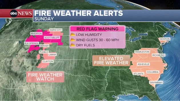
(LOS ANGELES) — Widespread elevated fire weather danger is expected to continue across parts of the Rockies and Great Plains on Sunday, as the Southwest is forecast to see another day of record-shattering March heat wave temperatures.
Wind gusts across the Plains are forecast on Sunday to reach 30 to 60 mph. Combined with very low humidity and dry fuels, conditions could be conducive for rapid wildfire growth and spread.
The National Weather Service has issued red flag fire-danger warnings for much of the Rockies.
While not currently on alert, parts of the mid-Atlantic and Northeast will also see dry and breezy conditions on Sunday, with dry fuels contributing to an increased fire threat.
Meanwhile, the Southwest will continue to bake as a record-shattering March heat wave continues on Sunday, a day after several record-high temperature marks were matched or exceeded.
At least 18 cities across California, Arizona, Colorado, Wyoming, Nevada and Utah either broke or tied daily records on Saturday, including Yuma, Ariz., which hit a new daily record of 102 degrees; Death Valley, Calif., which reached 100; Phoenix, which saw temperatures soar to 96; and Las Vegas, which hit 92.
Relief from the Southwest heat wave is expected to come later this week, but not before another day of record-breaking temperatures.
Daily record highs are possible on Sunday and Monday in Las Vegas and Phoenix, with some daily record highs possibly being challenged in the Great Plains on Monday.
As the workweek progresses, a pattern change will bring warmer than normal temperatures and messy weather for the eastern half of the nation.
Overnight Monday and into Tuesday, a weak system is forecast to pass from the Upper Midwest through the Great Lakes, bringing showers and thunderstorms, some of which could be strong enough to produce gusty winds, isolated small hail, and spotty flooding.
By late Tuesday and into Wednesday, the system will continue to pass through the Great Lakes and eventually into the Northeast, spreading scattered showers and rain into the Northeast.
More messy weather is forecast through Wednesday and Thursday across the eastern half of the nation, mainly with scattered showers and some thunderstorms.
As April arrives on Wednesday, the weather pattern will start to change, likely bringing warmer-than-normal temperatures for the eastern half of the country. The West could also experience warmer-than-normal temperatures returning as April progresses.
What’s likely to remain consistent across the West is drier-than-normal weather, adding to an ongoing drought and record-low snowpack across the West.
Copyright © 2026, ABC Audio. All rights reserved.